Council responds to sea wall controversy
Dublin People 30 Oct 2015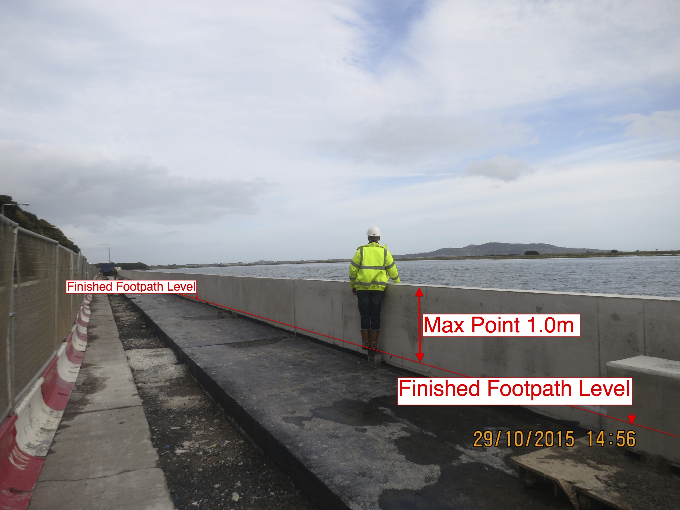
DUBLIN City Council has issued a statement outlining its position regarding the Sea Wall controversy which is continuing to rage on the Northside.
Local residents are up in arms while the city council constructs a flood defence wall on the coast road near St Anne’s Park.
The wall is being built as part of the Sutton to Sandycove (S2S) project.
The scheme comprises elements of two projects: the Dollymount Promenade & Flood Protection Project (DPFPP), and the North City Arterial Watermain (NCAM), both of which have planning approval from An Bord Pleanála.
Dublin Bay North TDs Finian McGrath (Ind) and Terence Flanagan (RENUA Ireland) are among the local public representatives who have expressed concerns over the wall currently under construction.
Deputy McGrath said: “I am vehemently opposed to the construction of this wall. I am also taking strong and direct action in order to halt the ongoing construction to give space for a resolution to be found.
“I am working along with my Independent colleague Cllr Damian O’Farrell and we have contacted Owen Keegan, chief executive of Dublin City Council, demanding that construction is halted.
“We have also called for a meeting between public representatives and Dublin City Council engineers which is going to take place on November 5.
“Furthermore, in order to send a very strong message to DCC I have organised a public meeting for Wednesday, November 4 at Clontarf Castle (7.30pm).”
Deputy McGrath added: “I am working alongside Damian (O’Farrell) on other courses of action, and the matter will also be raised at the next full City Council meeting.”
Deputy Terence Flanagan said: “A number of local residents have contacted me to highlight their concerns about the concrete wall that has been constructed along the sea front at the junction of Watermill Road, Causeway Road and James Larkin Road.
“They are very worried that the wall will seriously impede the view of the Bay from the road and have a negative impact on what is an area of natural beauty and conservation.
?¨
?¨
“A number of people have highlighted that this area is not historically a problem flooding area and the need for a sea wall of this height is questionable.”
Deputy Flanagan added: “Local residents are angry that there was not more consultation with them about the proposals.”
?¨
Dublin City Council statement in full:
The Sutton to Sandycove (S2S) project is a scheme comprising elements of two projects, the Dollymount Promenade & Flood Protection Project (DPFPP) and the North City Arterial Watermain (NCAM), both of which have planning approval from An Bord Pleanála.
Subsequent to the planning approval by An Bord Pleanála of the DPFPP in December 2011, Dublin City Council (DCC) and the National Transport Authority (NTA) received Part 8 Planning approval for this scheme in May 2013.
The scope of works includes the construction of two new sections of retaining wall and improvements to the existing sea defence wall. These works include height adjustments to the existing sea wall to ensure a statutory minimum level of flood defence is provided.
The proper Part 8 consultation procedures were followed. The proposed scheme was advertised on the DCC website and a public ad was placed in Irish Times.
A total of 14 site notices were erected at key locations from the Wooden Bridge to north of Causeway Road and at all major traffic junctions along the route.
Plans and particulars of the proposed scheme went on display for public inspection in the Civic Offices, Wood Quay and in the local Library at Raheny, and a total of 43 submissions were received which resulted in two amendments to the final proposed scheme.
The proposal was presented to the North Central Area Committee in September and November 2012. A public information meeting, hosted by the Clontarf Residents Association and attended by 180 people, took place in January 2013 in Belgrove Girls School Hall, Seafield Road with a follow-up meeting in May 2013 in the Northside Civic Centre in Coolock.
Public representatives and residents attended this meeting. The NTA and their project consultants Roughan & O’Donovan were present and dealt with any additional or new queries that had not been addressed in the already comprehensive consultation. Planning approval was granted on 13th May 2013.
The section of the project involves the construction of 2km of cycle track, additional flood protection measures and the laying of a trunk water main. The wall is required to protect against coastal flooding in this area. In a coastal area deeper water level will generate higher waves. With large portions of Bull Island likely to be flooded in the future due to a rise in sea levels, this section of the coastline will be much more exposed to wave action and the wall height is the minimum recommended to combat this.
The wall will not impact on sea views for pedestrians or cyclists on the seafront. It is important to note that the project is currently a work in progress and the footpath has yet to be constructed. Due to the low level of the roadway opposite St. Anne’s Park motorists will have significantly restricted views. On completion, the highest point of the wall along the route will be 1 metre (3 feet 3 inches).
As part of the process a glass wall was considered, however, it was considered to be unsuitable for the following reasons:
•There would be a significant difficulty with it handling impacting waves which ruled out this possibility.
•This would involve rebuilding most of the existing sea wall, not just a small portion of it under the current scheme.
•In locations in the city where Dublin City Council has installed glass panels there are very significant maintenance costs due to vandalism.
•The cost of the glass panels is a multiple of the current flood alleviation measure.
•The extra cost for a glass panel project would be €5 million to €10 million more than the current proposal, with no funding stream for it.
The final finish/render for the wall is under consideration by the council at the moment and while the proposed rendering complies with the planning permission that was granted, a change to the current finish is under consideration.
?¨
When completed there will be an overall increase in the provision of discretionary car parking in the area.
The project is due to be completed by the end of 2016.
For images/maps of the project please click here
For a list of FAQs please click here
Related News